

Adventures Along Historic Route 66
Exploring California and Arizona
A good portion of the first two days of our trip were spent driving along the remnants of Route 66, one of the first highways in the United States. It opened in 1926 and runs almost 2,500 miles from Chicago to Los Angeles. Throughout the years, it's been called The Mother Road and America's Main Street, and was one of the main arteries used by westward-bound settlers. Much of the original road is gone now, mostly replaced by Interstate 40 in the areas we traveled, but portions of it still exist. Sometimes these are small stretches of dead-end frontage road and others are whole sections that stretch for miles.
Elmer's Bottle Tree Ranch
The first stop on our journey was only about 90 minutes outside of Los Angeles along the National Trails Highway (which was also part of Route 66 before it was decommissioned), was Elmer's Bottle Tree Ranch.

Elmer's Bottle Tree Ranch
Some gent named Elmer Long, using the countless bottles that he and his father collected for many years, created a dense forest of bottle trees on a portion of his land in Oro Grande, California. Each tree is a metal pole with numerous coat-rack like arms, each of which is adorned with a bottle. Amidst all the glassware, visitors will encounter many old highway signs and all sorts of oddities and anachronistic detritus, like typewriters, cash registers, automatic weapons, and even an old, broken-down Willy's jeep.

Willy's jeep at Elmer's Bottle Tree Ranch
It's a fantastic, even magical, place to visit—and it's completely free, although Elmer does accept tips visitors can drop into a large mailbox near the entrance.
Freight Trains
As we drove through the Mojave Desert, we saw many freight trains (upwards of 15 on our first day alone) chugging along on the tracks running adjacent to the highway. It was kind of amazing how many there were moving through this area, transporting goods across the nation. There are a lot of goods.

Stopped by a freight train along Route 66.
We even got caught at a railroad crossing along Route 66 on our way to Amboy. It wasn't too long (the girls counted 212 cars, most of them carrying two shipping containers). I was sad that it didn't have a caboose. The caboose, like Route 66, seems to be a relic of the past.
Amboy, California
Amboy was once a vital water stop along Route 66, but today it's just a ghost town with a population of four. Although there are a few sites of geologic interest nearby (the extinct volcanoes known as the Amboy and Pigsah Craters) in Amboy itself there's really only one place to visit—and that's Roy's.
Roy's Motel and Cafe
Roy's first opened in 1938, catering to the many travelers along Route 66. It closed in 1995 after the owner sold the whole town.

Roy's Motel and Cafe.
For a decade, Roy's sat abandoned, falling into disrepair. It was used only for the occasional photo or movie shoot. In 2005, Roy's (along with the whole town of Amboy) was bought by Albert Okura (owner of Juan Pollo restaurants—he also owns the original McDonald's location in San Bernardino). After some renovations, Roy's reopened in 2008.
While it's no longer a motel nor a cafe (although you can get cold drinks there), the cafe portion serves as a small Route 66 museum and gift shop. Over at the motel, the entrance is set up like a check-in desk, but it's just for show, and the buildings outside host a series of art installations.
You can also fill up with gasoline from a pair of old-style pumps, but it's expensive—when we were there the price was $4.99 a gallon (compared to $3.29 in other less remote California towns).
Guardian Lions
About a mile east of Amboy, sitting in the desert just off the road, a pair of Chinese guardian lions keep watch over the desert.

The male guardian lion, keeping watch over the Mojave.
They sit roughly a quarter-mile apart. Such lions are usually found in pairs, one on either side of a gate or doorway. We had to wonder what sort of entry they're guarding way out here.
Kingman, Arizona
Unlike many towns we encountered along Route 66, Kingman seemed to be pretty busy and, for a town in the Mojave Desert, was quite large. Kingman, named for Lewis Kingman, who surveyed the land for the railroad, was founded in 1882 before Arizona was a state.
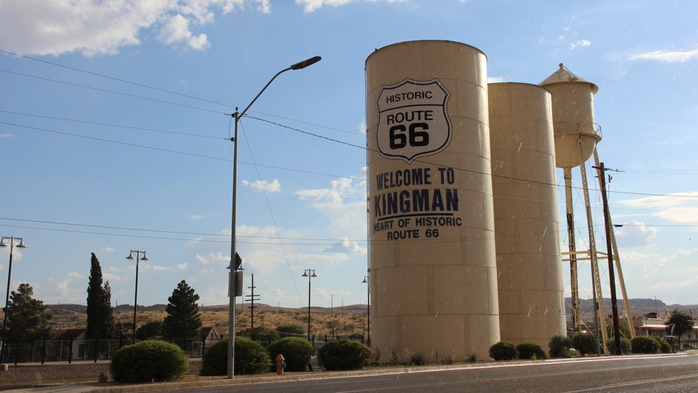
Kingman, Arizona
Kingman is home to the Powerhouse Route 66 Museum, which we didn't get to visit. It closed about half an hour before we arrived in town and didn't open until 9:00 the next morning. We had a big day of driving ahead of us, so we planned to leave town by 8:00 a.m.
Mr. D'z Route 66 Diner
This landmark diner is a throwback to the classic car culture of 1950s America, and the interior is decorated with pure vintage Americana.
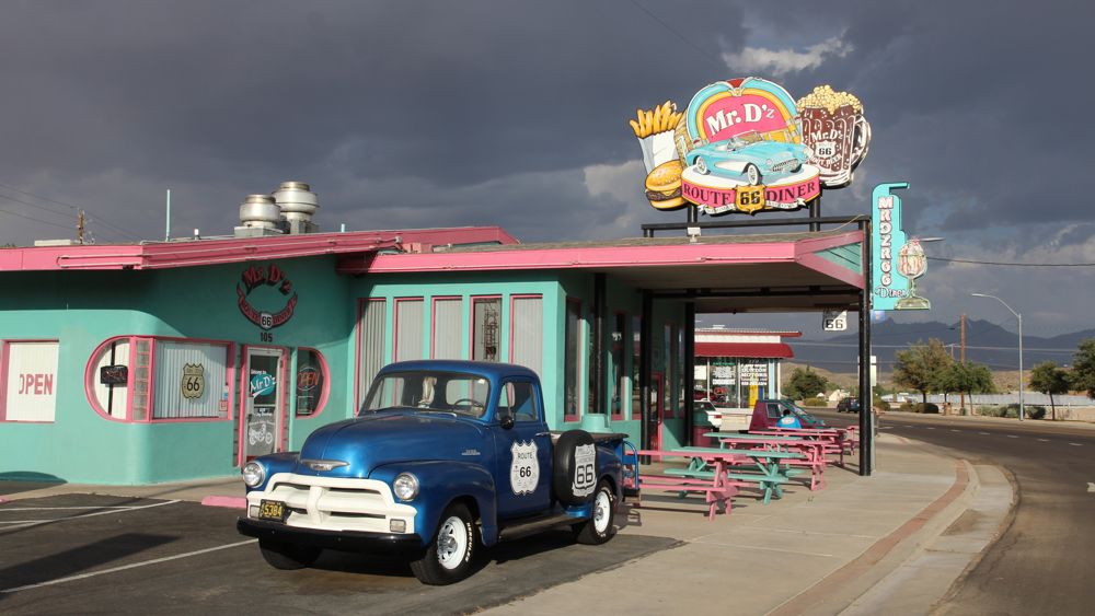
Mr. D'z Diner in Kingman.
This restaurant, a Kingman destination since the 50s, is listed in many guidebooks as a place travelers must visit, so we decided to give it a try. The food wasn't bad, but they're definitely trading on the appeal of nostalgia. The house-made root beer is pretty good, though.
Kingman KOA Journeys
Our first night was spent at the Kingman KOA, which was a pretty nice place to park our Jucy Trailblazer for the night.

Our JUCY Trailblazer nestled into a campsite at the Kingman KOA.
The only problem we had here was one of temperature—Kingman is hot, and sleeping inside a camper van proved to be a challenge. There wasn't too much in the way of airflow through the van, so we slept with the doors open, which helped a bit. But we were in the Mojave Desert in July, so there wasn't any escape from the heat.
Historic Route 66
One of the longest intact stretches of Route 66 runs for nearly 100 miles between Kingman, Arizona to Seligman, Arizona. Along the way, it passes through Valentine, Truxton, and a few other ghost towns that have all but vanished. We were hoping there was more history to see along this section, but it was pretty desolate. Still it was nice to be driving on Route 66.
Burma-Shave Signs
Along this lonely stretch of road, drivers can see one of Route 66's most enduring legacies—the small signs promoting Burma Shave, a brand of brushless shaving cream introduced in the 1920s, that were some of the earliest roadside advertisements.
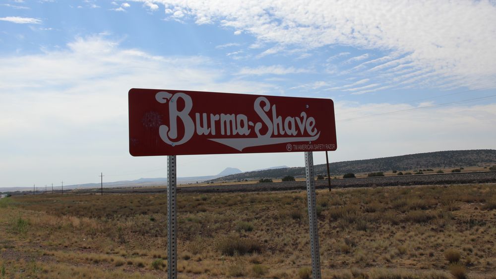
Burma-Shave
Once Burma Shave started placing these catchy signs next to the early highways of America, like Route 65 (in Minnesota, near the company headquarters) and Route 66, sales took off. The Burma Shave signs, typically placed in a series of six (the last of which just said "Burma-Shave") are quite small, and at today's highway speeds zip by rather fast. Ironically, the signs you can see today are just erplicas. The advertisements were never placed along this stretch of road in Arizona—even back then there wasn't enough traffic.
If you're interested in seeing the what the signs said, visit this archive of all the Burma Shave jingles.
Seligman, Arizona
Seligman, Arizona. Seligman is best known these days as the model for Radiator Springs in the movie Cars. And Seligman doesn't want you to forget that—all over the town you'll find real cars with eyes painted on their windshields. Unlike Kingman, which felt like an active small town, Seligman is pretty sleepy—its primary appeal is its connection to Historic Route 66.
Delgadillo's Snow Cap Drive-In
This iconic restaurant, sitting on the eastern edge of Seligman, was bult in 1953 by Juan Delgadillo, located just down the street from where his brother Angel (who founded the Historic Route 66 Association in 1987) had opened his his barbershop in 1950. The barbershop is now a Route 66 gift shop, but Delgadillo's Snow Cap is still serving up burgers and ice cream to road-weary travelers.

Delgadillo's Snow-Cap
The restaurant is still run by the Delgadillo family. Juan's son John mans the counter now, and, apparently in the tradition of his father, is quite the showman. He delivers a visual pun for pretty much every item on the menu and playfully banters with each customer as they order.
Bearizona
Just outside of Williams, Arizona, we came across Bearizona, a drive-through wildlife preserve with bears (naturally), wolves, bison, bighorn sheep, and many other animals native to the region.
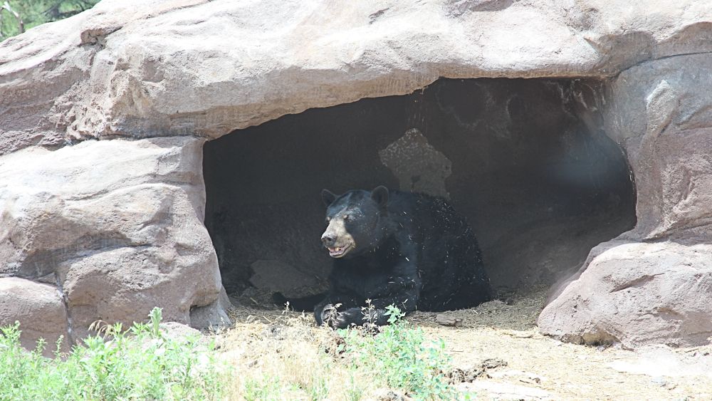
A bear lounging in a cave in Bearizona.
It was pretty expensive ($20 for adults, $10 for kids), but the gals were excited to check it out, so we paid the admission and drove in. The main feature of the park is a three-mile dirt road that winds its way through different habitats, each with its own featured species. It was like Jurassic Park, but with mammals instead of dinosaurs.
When you drove through the wolf and bear sections of the park, signs warned you to roll up the windows and lock the doors. The weather was hot on our visit, so most of the apex predators just lounged about, trying to keep cool.

Arctic Wolves, avoiding the heat of the day.
Bearizona also offers a walk-through section, which looked more like a typical zoo. We opted out of that part. The day was getting long and we still had two more stops to make on our journey before the day was over.
After Bearizona, we left Route 66 and headed up toward the Grand Canyon. But we weren't done with Route 66 quite yet. We'd be back to explore more of this historic road's secrets later in our trip.
Thank you to our friends at JUCY for providing us a discount to make our journey possible. All opinions are our own.
Suggested Reading


Tom Fassbender is a writer of things with a strong adventurous streak. He also drinks coffee.


